In our latest blog post, our International Implementation Team are pleased to announce the launch of a new project in the Cayman Islands.
We are excited to announce that a new initiative has now begun that will bring advanced Earth Observation (EO) and remote sensing tools to the heart of terrestrial habitat monitoring in the Cayman Islands. Supported by Darwin Plus funding, the project, Building Capacity for Habitat Mapping and Condition Monitoring: Cayman Islands, aims to give the territory the skills and tools it needs to map and monitor its unique terrestrial habitats over time. JNCC will be working in partnership with the Cayman Islands Department of Environment (DoE).
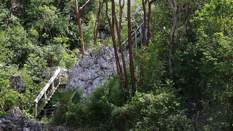
Image 1: The Hemmington Trail in Cayman Brac, showing the diverse and unique vegetation present in the Cayman Islands. The native flora comprises 415 plant species and varieties (photo credit: Cayman Islands Department of Environment).
Launched in October 2025 and running until June 2028, the project is funded by the UK Government through the Darwin Plus (Biodiversity Challenge Funds) programme, with a value of £335,344, with significant in-kind contributions from the Department of Environment (DoE) and JNCC, as well as in-kind support from Natural England.
Why this project matters
The Cayman Islands’ terrestrial habitats, including important mangrove forests, play a crucial role in biodiversity conservation and in supporting people’s wellbeing through flood protection.
The Cayman Islands are globally important for plant conservation, hosting an exceptionally rich and highly unique native flora. The strictly native flora includes 415 species and varieties of vascular plants, with 21 species found nowhere else on Earth and a further eight varieties that are unique to the Cayman Islands; at least ten of these have only been discovered in the last 15 years, showing how much there is still to learn.
This uniqueness is reflected in flagship endemic species, such as Cayman Ironwood (Chionanthus caymanensis), Silver Thatch Palm (Coccothrinax proctorii), Black Mastic (Terminalia eriostachya var. margaretae), the endemic shrub Corato (Agave caymanensis), several endangered island-restricted cacti, the critically endangered Grand Cayman Sage (Salvia caymanensis), and Cayman’s national flower, the Banana Orchid (Myrmecophila thompsoniae).
Cayman’s ancient forests support several key species, including endangered species unique to the Cayman Islands, such as the Cayman Brac Parrot or the Blue Iguana.
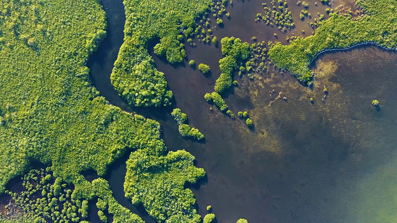
Image 2: Central Mangrove Wetland (CMW) from above. The Central Mangrove Wetland (CMW) is one of the largest contiguous mangrove forests in the Caribbean (photo credit: Cayman Islands Department of Environment).
Preserving Cayman’s native plant communities and terrestrial habitats directly supports people’s wellbeing by acting as natural "green infrastructure": mangroves and other coastal vegetation filter pollutants, improve water quality, and form a protective barrier that reduces storm surge, flooding and wind damage to homes and businesses in a hurricane-prone OT.
Recent work on climate resilience and ecosystem service valuation shows that Cayman’s natural habitats, including mangroves, forests and associated coastal ecosystems, provide tens of millions of pounds’ worth of protection and other services each year, underpinning the islands’ tourism economy, safeguarding property and infrastructure, and helping communities stay safer and more resilient in the face of climate change.
Building on a strong foundation
JNCC and the Cayman Islands Department of Environment already have a long-standing partnership. Previous work together includes a disaster resilience project funded by the UK Government’s Conflict, Stability and Security Fund, in which JNCC supported the Department of Environment to develop an inland flood model through a "learning by doing" approach. The Department of Environment now has the capability to run those models to inform planning decisions.
For this new work, Cayman offers an excellent testbed. The territory already has existing field data, an in-depth vegetation classification, and specialist expertise in forest ecology and GIS within the Department of Environment. JNCC brings more than 20 years of experience working with UK Overseas Territories and in developing EO-based condition indicators. Natural England, also a JNCC long-standing partner, is contributing its latest 'Living England / Living Maps' knowledge and providing technical advice, where needed. This is a tried-and-tested habitat mapping approach that uses largely open-source technologies and data.
Together, these strengths put the partnership in a good position to co-create methods that are robust, practical and embedded in the Department of Environment’s own systems from the outset.
Looking ahead
As the work gets underway, JNCC and the Cayman Islands Department of Environment are working closely to co-design methods that are technically robust, locally relevant and practical to apply. By the end of the project, the Department of Environment will have the skills, tools and frameworks needed to generate detailed habitat maps and assess the condition of key vegetation types, so that important tracts of mangroves, forests and other vegetation can be kept in good health. This will allow the Department of Environment to detect habitat loss or gain, pinpoint rare and at-risk habitats and respond quickly when degradation is detected.
In turn, this will strengthen conservation management and natural capital accounting, build resilience to pressures such as development, invasive species, climate change, and hurricane damage, and offer a model that could be adapted for other UK Overseas Territories.
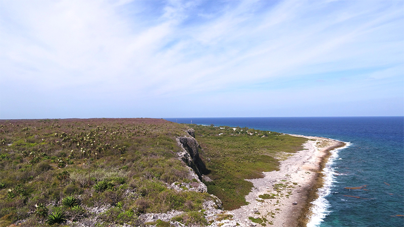
Image 3: The Bluff at Cayman Brac, the highest point in the Cayman Islands (photo credit: Cayman Islands Department of Environment).
This project is fulfilling the following goals from the newly launched UK Overseas Territories Biodiversity Strategy.
![]() Developing skills and talent
Developing skills and talent
![]() Enhance environmental resilience
Enhance environmental resilience
To learn more about the goals please visit Part 1 of the UK Overseas Territories Biodiversity Strategy.
For more information about the project:
- Project webpage (JNCC website): Building Capacity for Habitat Mapping and Condition Monitoring (Cayman Islands)
- Project webpage (Darwin Plus website): DPLUS122
Published: